
20 October 2026
What changes the cost of a concrete GPR scan?
The cost of a concrete GPR scan depends on the area and detail of the investigation, access to the surface, the work needed to interpret the signals and the results required afterwards. Two jobs with the same floor area can involve different amounts of scanning and analysis.
A square metre tells you how much surface there is. It does not tell you how much information needs to be collected from that surface. That distinction helps explain why a single online price cannot describe every ground penetrating radar investigation.
For a proposed opening, penetration or other change to concrete, Sirius Concrete Cutters’ concrete scanning service provides a starting point for discussing the investigation on the Gold Coast or in Brisbane. Understanding how a scan is built up makes the differences between scopes easier to recognise.
The instrument collects signals along a route
GPR sends electromagnetic pulses into a material and records returning reflections. As the antenna moves, successive measurements build a profile along its path. The display represents signal responses; it is not a photograph with every hidden object already named.
The Federal Highway Administration’s explanation of GPR in concrete describes data collection, processing and interpretation as separate tasks. Its bridge examples also show why reinforcement and the material’s electrical properties can affect what can be investigated. Survey design therefore needs to match the question being asked.
For a buyer, this means that moving an instrument over a floor and producing useful information about a particular proposed change are different amounts of work. The investigation needs a defined area, suitable coverage and an interpretation that relates the recorded responses to that area.
Area and distance travelled are different measures
Imagine the same square drawn twice. In the first drawing, five straight tracks cross it in each direction. In the second, nine tracks cross it in each direction. The square has not grown, but the second drawing contains eighteen full-width passes rather than ten.
If every pass has the same length, that is eighteen lengths of travel compared with ten. The comparison explains the geometry: closer tracks create more collection paths within the same area. It does not convert into a matching percentage change in a bill, because collection is only one part of the work.
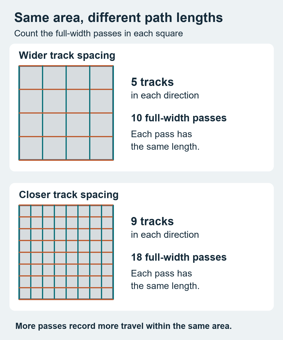
- Both panels show the same square. Teal vertical tracks and orange horizontal tracks each run across its full width.
- The upper panel contains five tracks in each direction: ten full-width passes. The lower panel contains nine tracks in each direction: eighteen full-width passes.
- For equal-length passes, closer spacing increases the total path length while the surface area stays the same.
The useful question is what the coverage needs to establish. Investigating several nominated penetration locations and mapping a larger region are different tasks. A price based only on the outside dimensions can hide that difference. The purpose and required detail of the investigation belong alongside the area.
A clear rectangle differs from scattered small patches
Ten small locations do not necessarily behave like one continuous location with the same total area. Moving between them, establishing where each sits and keeping the results tied to the correct location all add steps. Those steps exist even when the instrument spends a short time over each patch.
Access also changes the route the antenna can follow. A clear floor provides a different working surface from one interrupted by fixed plant, edges, walls or stored materials. An obstruction can prevent a planned path from being completed; it does not disappear from the investigation simply because it occupies little floor area.
This is why a floor plan and the physically accessible surface can describe different coverage. A scan of the accessible portions should be understood as those portions. An unexamined strip behind an obstruction remains a gap in the available information.
Collecting more data and resolving an answer are different things
Returns from several features can overlap, while strong reflections near the surface can make deeper information harder to interpret. A simple-looking slab can therefore produce a less straightforward question than its dimensions suggest. More passes may help investigate a response, but they do not guarantee that every uncertainty can be resolved.
Depth adds another distinction. A return time has to be interpreted using an appropriate wave speed; the number displayed on a time axis is not itself a depth. Our explanation of radar return time and concrete depth develops that mechanism with a separate diagram.
The amount of interpretation depends on the intended result. Recognising a repeating pattern and investigating an isolated, ambiguous response ask different questions of the recorded data. Neither the floor area nor the number of visible marks captures that difference on its own.
The result has to remain connected to its location
Surface marks are useful because they connect an interpreted finding with a place on the concrete. Once a mark has been covered, removed or separated from its context, its meaning is harder to recover. A record needs to show which area was examined and what the observations relate to.
A marked local investigation and a mapped record for a wider design discussion can therefore involve different work after collection. Photographs, location references, annotated plans and written findings serve different purposes. The required output affects what must be recorded while the area is accessible, as well as what must be prepared afterwards.
Scanning information also needs to be distinguished from permission to cut or drill. A reported feature, an uncertain response and an inaccessible area have different meanings. Decisions about structural changes and the proposed work still sit with the responsible project parties; a scan is one input to those decisions.
Compare the investigation behind the price
Consider two proposed scopes for the same room. One concerns a few marked locations associated with a defined change. The other concerns the layout of embedded features across a larger region, with an annotated record for later use. Both might be called a GPR scan, while describing different coverage and outputs.
For a proposed pipe penetration, the core drilling planning guide explains the related discussion about the hole, material and access. Keeping the investigation connected to that intended work helps make its purpose clear.
A useful comparison keeps those physical differences visible: the area actually accessible, the locations being investigated, the detail sought and the form of the findings. A smaller scope is not automatically poor value, and a larger scope is not automatically necessary. The question is whether the work produces information suited to the intended decision.
To discuss concrete scanning on the Gold Coast or in Brisbane, read our concrete scanning service information and get in touch with Sirius Concrete Cutters about the area and proposed work.